


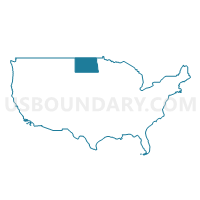
West North Dakota--Minot City PUMA, North Dakota
About
Outline

Summary
| Unique Area Identifier | 193682 |
| Name | West North Dakota--Minot City PUMA |
| State | North Dakota |
| Area (square miles) | 31,286.29 |
| Land Area (square miles) | 30,410.64 |
| Water Area (square miles) | 875.65 |
| % of Land Area | 97.20 |
| % of Water Area | 2.80 |
| Latitude of the Internal Point | 47.47925060 |
| Longtitude of the Internal Point | -102.41507080 |
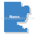
Maps

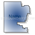
Graphs
Select a template below for downloading or customizing gragh for West North Dakota--Minot City PUMA, North Dakota


Neighbors
Neighoring Public Use Microdata Area (by Name) Neighboring Public Use Microdata Area on the Map
- East Central North Dakota--Jamestown City PUMA, ND
- East Montana (Outside Billings City) PUMA, MT
- Lakota Region PUMA, SD
- South Central North Dakota--Bismarck City PUMA, ND
- West South Dakota--Rapid City PUMA, SD
Top 10 Neighboring County (by Population) Neighboring County on the Map
- Burleigh County, ND (81,308)
- Ward County, ND (61,675)
- Morton County, ND (27,471)
- Stark County, ND (24,199)
- Williams County, ND (22,398)
- Roosevelt County, MT (10,425)
- Richland County, MT (9,746)
- McLean County, ND (8,962)
- Mercer County, ND (8,424)
- Mountrail County, ND (7,673)
Top 10 Neighboring County Subdivision (by Population) Neighboring County Subdivision on the Map
- Minot city, Ward County, ND (40,888)
- Dickinson city, Stark County, ND (17,787)
- Williston city, Williams County, ND (14,716)
- Sidney CCD, Richland County, MT (6,697)
- Beulah city, Mercer County, ND (3,121)
- Tatman township, Ward County, ND (2,992)
- Waterford township, Ward County, ND (2,807)
- East Morton UT, Morton County, ND (2,806)
- Dickinson North UT, Stark County, ND (2,616)
- Baker CCD, Fallon County, MT (2,522)
Top 10 Neighboring Place (by Population) Neighboring Place on the Map
- Minot city, ND (40,888)
- Dickinson city, ND (17,787)
- Williston city, ND (14,716)
- Minot AFB CDP, ND (5,521)
- Beulah city, ND (3,121)
- Hazen city, ND (2,411)
- New Town city, ND (1,925)
- Watford City city, ND (1,744)
- Bowman city, ND (1,650)
- Stanley city, ND (1,458)
Top 10 Neighboring Elementary School District (by Population) Neighboring Elementary School District on the Map
- Sidney Elementary School District, MT (6,817)
- New Public School District 8, ND (2,362)
- Nedrose Public School District 4, ND (2,315)
- Fairview Elementary School District, MT (1,321)
- South Prairie Public School District 70, ND (1,317)
- Billings County Public School District 1, ND (783)
- Yellowstone Public School District 14, ND (525)
- Baldwin Public School District 29, ND (420)
- Rau Elementary School District, MT (336)
- Eureka Public School District 19, ND (313)
Top 10 Neighboring Secondary School District (by Population) Neighboring Secondary School District on the Map
Top 10 Neighboring Unified School District (by Population) Neighboring Unified School District on the Map
- Bismarck Public School District 1, ND (77,337)
- Minot Public School District 1, ND (48,604)
- Mandan Public School District 1, ND (22,628)
- Dickinson Public School District 1, ND (20,772)
- Williston Public School District 1, ND (15,952)
- Beulah Public School District 27, ND (4,607)
- Bottineau Public School District 1, ND (4,112)
- Rugby Public School District 5, ND (4,023)
- McKenzie County Public School District 1, ND (3,724)
- New Town Public School District 1, ND (3,440)
Top 10 Neighboring State Legislative District Lower Chamber (by Population) Neighboring State Legislative District Lower Chamber on the Map
- State House District 47, ND (19,032)
- State House District 8, ND (18,870)
- State House District 37, ND (15,442)
- State House District 1, ND (15,230)
- State House District 5, ND (14,992)
- State House District 3, ND (14,922)
- State House District 33, ND (14,289)
- State House District 31, ND (13,907)
- State House District 36, ND (13,851)
- State House District 2, ND (13,822)
Top 10 Neighboring State Legislative District Upper Chamber (by Population) Neighboring State Legislative District Upper Chamber on the Map
- State Senate District 28, SD (19,903)
- State Senate District 47, ND (19,032)
- State Senate District 8, ND (18,870)
- State Senate District 19, MT (18,732)
- State Senate District 20, MT (18,169)
- State Senate District 18, MT (17,057)
- State Senate District 37, ND (15,442)
- State Senate District 1, ND (15,230)
- State Senate District 5, ND (14,992)
- State Senate District 3, ND (14,922)
Top 10 Neighboring 111th Congressional District (by Population) Neighboring 111th Congressional District on the Map
- Congressional District (at Large), MT (989,415)
- Congressional District (at Large), SD (814,180)
- Congressional District (at Large), ND (672,591)
Top 10 Neighboring Census Tract (by Population) Neighboring Census Tract on the Map
- Census Tract 107, Ward County, ND (7,038)
- Census Tract 106, Ward County, ND (6,474)
- Census Tract 104, Ward County, ND (6,394)
- Census Tract 9537, Williams County, ND (5,735)
- Census Tract 105, Ward County, ND (5,691)
- Census Tract 109, Ward County, ND (5,521)
- Census Tract 103.02, Ward County, ND (5,365)
- Census Tract 9610, McLean County, ND (5,053)
- Census Tract 9635, Stark County, ND (4,924)
- Census Tract 9541, Williams County, ND (4,732)
Top 10 Neighboring 5-Digit ZIP Code Tabulation Area (by Population) Neighboring 5-Digit ZIP Code Tabulation Area on the Map
- 58701, ND (28,368)
- 58503, ND (25,734)
- 58554, ND (22,884)
- 58601, ND (21,078)
- 58703, ND (19,396)
- 58801, ND (18,371)
- 59270, MT (7,339)
- 58704, ND (4,770)
- 58368, ND (3,801)
- 58523, ND (3,619)